Geelong Running Festival
Competitive and Beginner friendly and Social and Fast and Scenic
Road


Sun 20 Sep 2026

9 Aug 2026 • 18 minutes read


One of my favourite things to do is plan a trail running adventure with friends. Thankfull, Victoria is packed with trail runs that reward a little effort: alpine ridge lines, coastal cliffs, deep forests and long days in wild places. From stunning coastal trails to all-day missions in the High Country, these are my 10 favourite trail runs in Victoria; routes I keep coming back to for the views, the challenge and the feeling of moving fast through wild places.


Towering trees, lush undergrowth, long steep climbs and a great township to base from. Oh, and it’s only 90 minutes from Melbourne.
Mount Donna Buang is a 1,300m verticle climb straight up from Warburton. Greenery galore, it’s great place to get some climbing and descending strength into the legs.
For something a bit more beginner friendly, you can run along the O’Shannassy Aqueduct Trail on the North side of Wurburton. This gives you all the majestic scenery of the area while not exposing you to the steep trails of Mt Donna Buang.

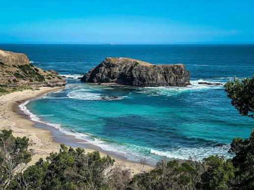

I love a point to point run that feels like you 'achieved' something. I also love that in this run your venture through a whole range of different eco-systems in less than 30kms.
From the rocky Arthurs Seat with views across Port Philip Bay, to the Xanthorrhoea (Grass Tree) filled Greens Bush, to the coastal cliff top views over Bushrangers Bay and Cape Schanck, every section of this run is exciting!
I also grew up just off this route and spent many of my first trail running years exploring this area, so it holds a special place in my heart.
Starting from the Dromana end and finishing at Cape Schanck requires a bit of a car shuffle as there's no buses. Cape Schanck is fantastic for a picnic afterwards and an explore of the cliffs and caves, but Dromana was lots of cafe and swimming options.


Bright is an outdoor enthusiast Mecca in Victoria, for mountain biking, paragliding, cycling and trail running. There are great runs in every direction, but I love the simplicity of a run up Emily's Spur to Mystic and back.
The paragliding take off gives awesome views back over Bright, but I also love that it fells like it gives you an excuse to pause and enjoy it. So many runs you keep on the move waiting to see what's around the next bend in the trail. But at Mystic you know it's time to slow down and enjoy it, before bombing back into town!
The climb up to Mystic is ~450m , but if you're feeling extra adventurous, you follow the route below can add on a detour up to the even higher summit of Clearspot.
Rules are often changing on which parts of the park you're allowed to access as a runner, so make sure you check Mystic Park website before heading off.


Controversial, even to myself. Falls Creek is stacked with option for getting steep... yet I've chosen the most pancake flat run possible (which is why I made sure to add on a bonus section at the start).
So often when trail running we spend most of our time staring at our feet, or the trail right in-front of us. One of the main things I love about the aquaduct trail at Falls Creek is because it's so flat and predictable you actaully have a chance to enjoy the remote alpine views!
The route I've attached below is from a run I did with Billy Kilbride, that actaully adds on a little more 'trail running' before joining the aqueduct. From where that route stops, at Langford Gap car park, is where you can often start your run. It's very common to start here and follow the trail South, towards Wallace's hut. In fact, that stretch is where many Australian distance road running greats have done their workouts over the decades!


Most of the other runs I've mentioned here are fantastic areas to run that I've cherry picked a few favourite sections of. The Great Ocean Walk on the other hand, a favourite section hasn't jumped out. That's not to say there isn't anything noteworthy, rather it's the immenseness of it all that makes it so appealing.
You can of course do smaller sections of the course, but to experience it in one push gives you such an appreciation for how dramatic this exposed area of Australia is.
I ran this course as my first 100km event (now the Great Ocean Trail Ultra) back in 2017, which I can also recommend!


Victoria's tallest peak and a practical loop... whats not to love?!
Starting and finishing at Mountain Creek Camping Area you have two options for completeing the loop. My favourite is going straight up Staircase Spur, with around 1,300m of climbing. This brings you up onto the Bogong High Plains with easy access the highest point in Victoria.
The other benefit of going straight up Staircase Spur, is then being able to enjoy the more runnable Eskdale Spur descent all the back to your starting point.
Climbing so steeply for so long, you get to see such dramatic change in ecology. Forrest, bush, alpine flowers, bare rough summit, and back again. All in 20km.


Anglesea area has so many good options with incredible sections from Torquay all the way to Aireys Inlet. My favourite area to explore is the large bush area just to the North East of town, but everywhere you'll find amazing pockets of natives that then pop you out to incredible ocean views.
Having grown up on the Mornington Peninsula (the other side of the bay) it pains me to say it, but this area absolutely takes the cake for getting into increadilbe landscapes straight from your doorstep.


The Grampians is like no other place I've been. I've have the fortune of running in places like Patagonia, Madeira, the French Alps and Death Valley, but Gariwerd still dazzles me. It's like you can see where tectonic plates have collided into each other leaving huge rock shelfs sticking up into the sky.
You find yourself rock hopping across the quartz sandstone. It almost feels like a big adverture park for trail running.
There's are so many amazing options, from Mt Zero and Mount Stapylton in the North, down to Mt Abrupt near Dunkeld in the South... but running around Halls Gap gives you so much variety.
There are no boring bits.


While Wilsons Prom itself is not under-rated, I strongly believe that going there purely for running is. People often travel so much further out of Melbourne, and while it doesn't have the towering peaks of the Alpine National Park, there's enough elevation to really bang your quads up. The loop below had 1,000m of climbing (don't beleive what it says 😉) and I didn't even summit Mount Oberon at the end!
This route in innaccesssbile by car, which is one thing I love about it. Without having trained, this loop is a multi-day hike with heavy backpacks full of expensive equipment.
Instead, this loop took me just over three and a half hours including breaks. With training, you can now move fast and efficinetly through nature, seeing things you otherwise might not have been able to.
At the time of writing, the track between the Start point of Telegraph Saddle Car Park and Sealers Cove is closed, so you need to do an out and back heading south and out to Waterloo Bay before heading north towards Refuge Cove.


I didn't have to think very hard about this one. The Razorback ridgeline linking Mount Hotham to Feathertop is the best stretch of training in Victoria in my opinion. What really sets this run apart, other than the long climbs and the exposed ridge line, is that the summit of Mt Feathertop is one of the few in all of Australia that feels like a true summit.
For a shorter run with much less elevation, you can do an out and back from Diamantina Hut where you get incredible views from the first to last step.
My favourite way to do it is to start and finish in Harrietville. From here, you can take Bungalow Spur Track straight up 1,300 vertical meters to the summit of Mount Feathertop. Then the cross the Razorback, an undulating exposed (but very safe) ridgeline to link up to Mount Hotham, before the big decent down Bon Accord Spur back to Harrietville.
The Great Dividing Range might not have the gradure of other mountain ranges around the world, but the Razorback to Mount Feathertop gives you a great glimpse into long consistent climbs and beautiful peaks and ridgelines.
I've to be pretty ruthless with which trails didn't make this list... head to the post on our Instagram and let us know which ones you think I got wrong!





Every event, every review, every club you love. Start your free RunDais account and keep it all in one spot.